[This post was originally published on The Living Room Tumblr.]
Tuesday was a strange day in Denver. After an awful week in which a terrifying wildfire down south, the #BlackForestFire, brought back the “state under siege” mentality of last summer, the drama shifted Tuesday afternoon from shadow and flame to lightning, wind and funnel clouds. This was a bit of a surprise. Although isolated severe weather was in the forecast, nothing too dramatic was expected for the metro area. But then, at 2:12 PM, my phone popped up an alert that a “Tornado Warning has been issued for Denver, CO.” #PANIC!
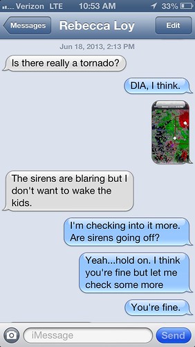
I promptly opened up the RadarScope app that, coincidentally, I had just purchased the previous day for $9.99 for use in exactly this sort of situation (without having any idea that I would need it the next day), to try and spot the tornado on the app’s near-real-time Doppler radar, and figure out where it was headed. While I was in the process of doing that, Becky texted me that tornado sirens were blaring in Stapleton; moments later, they started blaring downtown, too. Becky wanted to know if she needed to wake up the girls from their nap and take them to the basement:
I quickly determined that, no, there was no threat either to Stapleton or to downtown. There were two possible tornado signatures on radar, including one looking pretty definite, but both were east of the city proper, and both were moving north or east – away from the main bulk of the metro area. The only reason “Denver, CO” was under a tornado warning was because the portion of Denver known as Denver International Airport, which is attached to the rest of the city by a snake-like connective arm, was under threat. The sirens throughout the rest of the city were simply the result of outdated warning technology that hasn’t been updated to respond to National Weather Service “polygons.”
But while those of us in the “non-DIA” part of Denver could rest easy, DIA definitely couldn’t. This was more than just a radar signature (although the signature was pretty wicked) – a real, confirmed tornado touched down very near the airport, on DIA property. (Just in time for International Panic Day!) Passengers took shelter and flights were grounded. Soon, social media was filled with dramatic photos of the twister:
WHOA. RT @WCL_Shawn: WOW. | NEW PIC: #tornado at Denver Int’l Airport (via @jmilazz) | pic.twitter.com/uF0SWZPbsT | #COwx
— Brendan Loy (@brendanloy)
Denver International tornado RT @7Marshall: Thank you Brenda Deem #7newsNOW viewer. #DIA tornado #cowx pic.twitter.com/IMh4oRgOOx
— Weather Underground (@wunderground)
“There is a fell voice on the air.” “It’s the #demonhorse!!!” “He’s trying to bring down the airport!!!” pic.twitter.com/ylknmeQDS8 #cowx #LOTR
— Brendan Loy (@brendanloy)
That last picture, by Brian Horsfield (@Brister), is my favorite because it features the #demonhorse, a.k.a. Bluecifer. But what all three photos share is that they, and many others I saw, show the body of the tornado seemingly consisting of a fine brownish dust. That image was on my mind when, hours later, a few minutes before 9:30 PM Tuesday, I took the dog out to the back yard for her last chance to do her business before bedtime – and saw something very odd in the sky over Stapleton.
Because there was some lightning way off to the northeast, associated with another (non-severe) storm up near DIA, I had come outside with the dog, instead of letting her walk around the yard by herself, to watch the show. But then I looked up and noticed a very peculiar-looking cloud bank directly overhead. The sun had set an hour earlier, so it was getting quite dark, and it was hard to process exactly what I was seeing, let alone describe it accurately. But I tried to do so on Twitter, and sought guidance from KMGH meteorologist Matt Makens about what the hell it was:
@MattMakens247Wx Sky over Stapleton is weird. There’s like, a really low-hanging brown layer. Looks like…dust? But maybe just dusk lighting?
— Brendan Loy (@brendanloy)
@MattMakens247Wx The clouds directly overhead look oddly featureless. Not much wind… but sort of disconcerting.
— Brendan Loy (@brendanloy)
What I was pondering, as my “not much wind” comment implies, is whether I could be seeing some sort of nascent tornado. The little filaments of dust-like material hanging down from the clouds reminded me of those DIA tornado pictures, although they were certainly far less substantial. Even so, they made me #PANIC just a bit. But I took a close look and eventually concluded there was definitely no rotation. If anything, they were moving in a slow, erratic way, and then seemingly disappearing. So, no tornado. But still – what were they?
I decided to grab my SLR camera and try to get a long-exposure shot, so I could show Matt what I was talking about.
Weird featureless brown clouds w/ low-hanging layer over @StapletonDenver. Lightning moving E. #cowx @MattMakens247Wx pic.twitter.com/YzPBYjm46Q
— Brendan Loy (@brendanloy)
@brendanloy @StapletonDenver That is an odd cloud deck. Dropping some rain over DIA right now, too.
— Matt Makens (@MattMakens247Wx)
@MattMakens247Wx Isn’t it?? Glad to hear you say so, I thought maybe I was overreacting to dusk lighting effects. But yeah, it feels weird.
— Brendan Loy (@brendanloy)
Eventually I went back inside, and didn’t think much more of it. Then on Wednesday, the focus shifted from severe weather back to wildfires, as another nearby blaze broke out: the #LimeGulchFire, southwest of Denver. Also, a bunch of other fires broke out elsewhere in the state.
A few hours into the intense coverage of the #LimeGulchFire, news broke that the fire had actually started the previous evening:
#LimeGulchFire started yesterday around 6p. US Forest Service has taken control of blaze. http://t.co/YmexBT1DT0 pic.twitter.com/2MMXXuFy7M
— 7NEWS Denver Channel (@DenverChannel)
That got me thinking:
#LimeGulchFire began yesterday ~6p. Could weird Denver clouds ~9:30p pic.twitter.com/YzPBYjm46Q have contained its smoke? #cowx @MattMakens247Wx
— Brendan Loy (@brendanloy)
It did look like a smoky brown layer *below* the clouds. Dunno if storm came from SW, tho, or if fire was smoky enough yet. @MattMakens247Wx
— Brendan Loy (@brendanloy)
@brendanloy very possible that the water droplets formed on smoke particles. Certainly a good observation!
— Matt Makens (@MattMakens247Wx)
@MattMakens247Wx You said it went toward DIA, right? So that’d be about right, working backwards… (I’m fascinated by this idea now.)
— Brendan Loy (@brendanloy)
@brendanloy that storm developed near Golden, so a bit north of the fire…
— Matt Makens (@MattMakens247Wx)
@MattMakens247Wx Hmm. Maybe not then. Darn, I really liked the theory. 😛
— Brendan Loy (@brendanloy)
@MattMakens247Wx Then again, perhaps the clouds I saw were a little south of the main storm complex that hit DIA? #ClingingToMyTheory
— Brendan Loy (@brendanloy)
@MattMakens247Wx The lightning was definitely off to the north & east, and moving away, even while the weird brown dusty cloud was overhead.
— Brendan Loy (@brendanloy)
@brendanloy It’s a good theory.
— Matt Makens (@MattMakens247Wx)
So… did I, in fact, see an early sign of the nascent #LimeGulchFire, almost 30 miles away, in the form of a weird-looking brownish smoke layer clinging to a cloud’s water droplets (or vice versa) and parked at the bottom of a low cloud, many hours before widespread smoke and haze overtook the metro area the next day?
I can’t prove it, but it makes a lot of sense. And it would vindicate my feeling of unease. I knew something wasn’t right about that cloud! I was just thinking of the wrong kind of “thing” (i.e., severe weather and tornadoes, as opposed to wildfires).
Anyway, I’m gonna stand by my theory until someone proves it wrong. 🙂
Last night, @StapletonDenver saw a weird brown cloud w/ low dust(?): pic.twitter.com/YzPBYjm46Q Related to early-stage #LimeGulchFire? I wonder.
— Brendan Loy (@brendanloy)
(As I’m sure you all know, when I type “I wonder,” I’m mentally saying it in the voice of Ollivander in first Harry Potter film. Obviously.)
— Brendan Loy (@brendanloy)