
Welcome, InstaPundit readers! I apologize for the relative dearth of updates on today’s tropical developments, at least as compared to my hyperactive weatherblogging of years past. Alas, “free time” isn’t a terribly viable concept when you have a 19-month-old and a 1-month-old. 🙂 Indeed, I’m only able to post this update because the previously crying 1-month-old has finally fallen asleep inside the sling I’m wearing — a situation that could change at any moment!
But anyway, I will do my best to keep up with the tropics as they finally get going. And when I haven’t updated the blog recently, I encourage you to visit the other sites in my “Weather Blogroll” at right (which I’ve temporarily bumped up the sidebar a bit; it’s usually further down, with my other blogrolls).
To answer one reader’s question, I’ll be doing my updating here, not at Pajamas Media. I might do an occasional article for PJM, but not real-time updates, as the folks there have decided not to keep my PajamasXpress blog going this season. In other words, the “Weather Nerd” is dead, long live the Weather Nerd! 🙂
Anyway… after 2 1/2 months of tropical inactivity, making 2009 the ninth-slowest-starting season in recorded Atlantic basin history, things kicked into high gear Saturday with a sudden burst of activity. Tropical Storm Ana formed at 5:00 AM EDT, and Tropical Storm Bill followed suit 12 hours later, at 5:00 PM EDT.
(And, as if that weren’t enough, the NHC is tracking “Invest 91L” in the Gulf of Mexico, and the computer models are bullish on the latest wave coming off Africa. But let’s focus on Ana and Bill for now.)
While everyone is talking about Ana’s eventual track and potential intensity when she reaches Florida or the Gulf of Mexico, there is some question right now about whether she’ll even make it that far. Earlier Saturday afternoon, Dr. Jeff Masters wrote:
After an modest burst of heavy thunderstorm activity prompted NHC to upgrade Ana to a tropical storm early this morning, Ana has run into strong upper-level winds from the west that are creating high wind shear. This shear was not forecast, and it is not clear how long it will last. The shear has acted to drive dry air into the core of Ana, destroying almost all of Ana’s heavy thunderstorms. The low-level center of the storm is now exposed to view, something that often foreshadows the death of a storm. It is possible the shear will destroy Ana, and several models (the GFS and ECMWF) forecast this may be the case.
The National Hurricane Center’s 11:00 PM EDT discussion indicates the shear is continuing, and Ana remains in trouble:
THE CONVECTION NEAR THE CENTER OF ANA HAS BEEN PULSATING AND AFTER AN INCREASE FOR A FEW HOURS…THE LOW LEVEL CENTER HAS BECOME EXPOSED AGAIN. THIS MEANS ANA IS NOT STRENGTHENING AND THE INITIAL INTENSITY IS KEPT AT 35 KNOTS. . . . THE SHEAR IS NOT VERY STRONG AS DIAGNOSED BY THE SHIPS MODELS BUT THE LOW-LEVEL CENTER OF ANA IS SIMPLY MOVING TOO FAST. THIS RAPID MOTION IS PROBABLY NOT TOO CONDUCIVE FOR INTENSIFICATION. IN FACT…THE ONLY DYNAMICAL MODELS THAT KEEP ANA ARE THE UK AND THE NOGAPS. THE REST OF THEM WEAKEN ANA TO A TROPICAL WAVE. I AM TEMPTED TO SHOW WEAKENING BUT FOR NOW…I AM GOING TO FOLLOW THE PREVIOUS FORECAST AND SHIPS MODEL GUIDANCE. THE OFFICIAL FORECAST SHOWS SLOW STRENGTHENING THROUGH 48 HOURS FOLLOWED BY WEAKENING AS THE CYCLONE INTERACTS WITH HISPANIOLA AND CUBA.
In his above-quoted post, Dr. Jeff Masters wrote of Ana, “I give equal chances that the storm will be a hurricane — or non-existent — four days from now.” At the moment, “non-existent” is sounding a bit more likely, but we shall see.
Bill, on the other hand, appears likely to strengthen steadily. It is a bit further south than Ana, over warmer waters, and forecast to encounter less wind shear, dry air and Sarahan dust than its sister storm has. The official forecast has Bill reaching hurricane intensity in 2 days, and close to major hurricane intensity in 5 days. Some of the intensity models are even more aggressive, as Eric Berger notes. In sum, although such things are never certain at such an early stage, it appears that Bill is fairly likely to become a monster.
The big question, of course, is where Bill will go. There is, at least provisionally, some good news on that front. The official forecast has bent to the right since the last advisory, following the computer models. FLhurricane.com summarizes: “Bill’s models are trending toward the possibility of staying away from the mainland United States, but its not guaranteed yet. It needs to gain latitude first, and it may move more westward if it stays weaker.” If that’s the case, then early intensification would actually be good, increasing the likelihood of Hurricane Bill becoming one of those beautifully ferocious “fish” storms that we can all admire in peace and safety, far out at sea.
I’ll end with one last, unrelated note, for those readers who might want to talk about hurricanes and climate change. As regular readers know, this blog is agnostic on that topic, and it drives me nuts when people (on both sides) confuse weather and climate, and insist on making every weather-related discussion an excuse to talk about global warming. However, Eric Berger has a pretty good post addressing the question of what 2009’s late start means, if anything, for the AGW/hurricane debate, and I figure it’s worth quoting here:
Around the year 2005 environmentalists were eager to point to hurricanes as a concrete, real-world example that global warming was already having a negative impact on the United States. Some of that rhetoric has since cooled, with quieter seasons, and most scientists admit there’s still much uncertainty about how a warmer world will affect storm activity.
Now, with the slow start to 2009, the pendulum has swung, and critics of global warming are using this as evidence to ridicule climate scientists. It’s just not that simple. We can’t look at hurricane activity in any one year and learn anything about long-term trends. It doesn’t work that way.
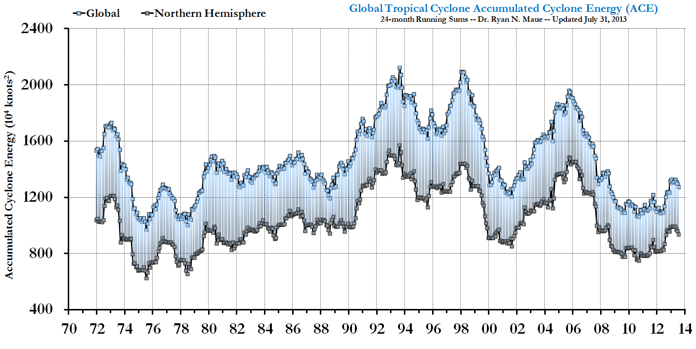
What we do know, thanks to research by Ryan Maue, is that storm activity both globally and in the Northern Hemisphere is approaching the lowest point it’s been at since the late 1970s, when we had satellites to survey tropical weather around the globe.
[Berger’s post includes a nifty chart of this, which I’m too lazy to reproduce here. 🙂 Go there to see it.]
We don’t know what this means yet.
Pingback: Instapundit » Blog Archive » MORE ON TROPICAL STORMS ANA AND BILL, from Brendan Loy….
Glad to see you…Assumed the dearth of postings was related to the dearth of tropical activity…
–John
It is remarkable how quickly Claudette has strengthened. I am 35 miles north of New Orleans. This is the type of storm where we may get 5 inches of rain or none.
Growing up I almost enjoyed the excitement of hurricane season. Katrina cured me.